Mapbook Luddite, that’s me.
Even though my car has a navigation system and my iPhone has Google Maps, I’m still a fan of paper maps. In the car when I was little, my dad would hand me the map to read, probably to shut me up. During the Disney years, I recall marking one map of Florida with the exit in Orlando that had the Waffle House, which is a really, really important thing to be able to locate. I’ve never gone on a road trip without an atlas and I dare anyone to be more proficient than I am at the ancient art of map folding. On girls’ weekends, I’m the one with the map book, navigating us around. When I complained about it once and stated that next trip it would be someone else’s turn to lead us around, my girlfriend C shot back with, “I don’t think you can give it up!” Funny and true. Whenever we travel, I buy a map book and study it before we leave. It came in handy this past summer in London during the Olympics. The mapbook worked quite well when the cell-towers were overburdened.
I still have a road atlas in my car, but it’s been relegated to a bin I keep in the back cargo area that allows my dog and I to be prepared for any adventure that might come our way. In addition to the atlas, there are towels, a few tennis balls, an extra Chuck-it, a long line, some Musher’s Secret, a backpack, two water bowls and other items that allow us to take a hike anywhere if we feel like it. When we’ve had a lot of fun, the bin gets disorganized, so I decided to tackle the mess we had made after a few jaunts into the woods.
I ended up dumping the bin upside down and this fell out from beneath a bunch of towels. Wow. A blast from the time before I toted an IPhone and before my car had a nav system.
Dog-eared diary of a Chicago newbie by Amy Knebel
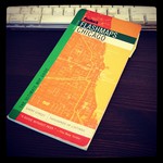
It’s a Fodor’s Flashmaps of Chicago; I bought it in late 2004, right after my husband left to start a new job there and I was back in DC packing us up. I remember going to the Barnes and Noble at Clarendon and scrutinizing 6 or so different Chicago map books before settling on this one. On a few trips to Chicago before the move was complete, I spent my air time marking maps with my favorite mechanical pencil. “OK, we will be living here. John’s office is here. I take the ‘L’ this way to get to Marshall Field’s.”
For the first six months in Chicago, I never left home without that map book. It was always in my purse and I was glad to be old enough to be completely OK with looking like a tourist as I stood on a corner trying to get un-lost. The day that I really made Chicago home was the day I accidentally left it at home and ventured far and wide (within the city limits) without needing to consult it or freaking out.
The inside is a cartographical diary of the days before our phones’ maps kept us on the beaten path. One note is the address of the camera shop in the Viagra Triangle where I bought John a nice pair of binoculars for his birthday. Another series of notes helped me Red Line and bus it to South Shore for a teacher expo. Another note is directions to a dear friend’s home. Check marks kept track of places we dined, imbibed, shopped and gazed. When I think about it now, the way I learned the city is the best way, technology-free, Luddite-style.
We’re getting ready to move into DC from Arlington and I’ll be the first person to admit that I’m a little giddy at the prospect of selecting a new map book for DC and marking it up. It’s been 1o years since we lived downtown and a lot has changed. I’m sure to get turned around and lost. How will you know it’s me? I’ll be the Luddite with the map book on the corner.